Hovedbanegård (Copenhagen)
There are 2 photos from Hovedbanegård (Copenhagen) and 2 trams in the direction of Hovedbanegård (Copenhagen) on Tram Travels.
Københavns Sporveje (KS) stops
Åboulevard, Ålestrupvej/KB Hallen, Ålholm Plads, Axeltorv, Bispebjerg, Blågårds Plads, Blegdamsvej, Bodenhoffs Plads, Brønshøj, Christiansborg Slotsplads, City Hall Square, Degnemose Allé, Dyrehaven, Dyrskuepladsen Bellahøj, Emdrupvej, Femvejen, Formosavej, Frederiksberg Runddel, Frederiksholm Sydhavns Plads, Frederiksvej, Frihedsstøtten, Fuglebakken, Gammel Torv, Hans Knudsens Plads, Hellerup, Holmbladsgade, Hovedbanegård, Husum Torv, Kammasvej, Kongens Nytorv, Lille Vibenshus, Mozarts Plads, Ndr. Fasanvej, Nørre Farimagsgade, Nørrebro, Nørrebro Station, Nyelandsplads, Øresundsvej, Østerport Station, Polititorvet, Ryparken, Sjællandsgade, Slotskroen, Strandboulevarden, Studiestræde, Sundby, Sundby Hospital, Sundbyvester Plads, Svanemøllen, Taksigelseskirken, Toftegårds Plads, Trianglen, Trommesalen, Valby (Skellet), Vanløse, Vanløse, Ved Langebro, and Vibenshus Runddel.
Københavns Sporveje (KS) depot
Allégade, Århusgade, Enghavevej, Nørrebro Remise/Nørrebrohallen, Sporvejenes Hovedværksted, and The old Valby depot.
Photos and videos from Hovedbanegård (Copenhagen)
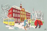 Postcard: Copenhagen tram line 13 near Hovedbanegård (1948)By Carl A. Thejll. Kunstforlag, Henrik Boye.
1948.
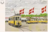
 Postcard: Copenhagen animal show line Buh at Central Station (1943)By Henrik Boye, John Lundgren, Sporvejshistorisk Selskab (SHS).
July 1943.
Location on a map
Trams in the direction of Hovedbanegård (Copenhagen)
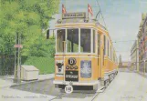
 Postcard: Copenhagen animal show line Buh on Borups Allé (1963)By Henrik Boye, Sporvejshistorisk Selskab (SHS).
June 1963.
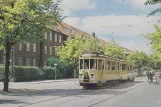
 Postcard: Copenhagen animal show line Buh at Dyrskuepladsen Bellahøj (1938)By Henrik Boye, John Lundgren, Sporvejshistorisk Selskab (SHS).
July 1938.